M1MT: Large city management system

Improve the rational management of all spheres of life of a big city – it’s land and labor resources, housing and communal services, road and transport, and engineering and communication systems with the help of M1MT: Large city management system. Increase the living standards of local residents and the quality of services provided by the executive authorities, and efficiently manage the economy, sports and leisure industries for residents and guests of the municipality. The city, managed through GIS, is open to cooperation with investors, will become a model example of the organization of municipal management.

Implementing the product M1MT: Large city management system will ensure the coordinated operation of public utilities, optimize the cost of the city for road and communications repair, the development of municipal infrastructure, reduce accidents, solve the problem of sound planning and increase budget revenues, analyze and improve the overall energy efficiency of utility networks.
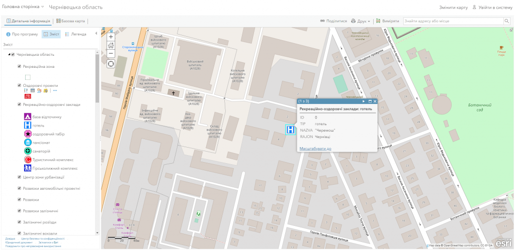
Optimize the work of the Department of Urban Development and Architecture

  • ensure publicity in the management of urban planning, the joint solution of the problems of the city, increasing the comfort of living of the population and improving the quality of the urban environment;
  • provide citizens with access to information on the state of the environment, the real estate market, transportation, and the provision of other information and reference and educational geo-information services;
  • perform an automated search for information and a detailed view of data on objects, including in a combination mode with popular map resources (Google Maps, OpenStreetMap, BingMaps);
  • automate the processes of maintaining the address registry, address plan of the city, register of streets and objects thanks to the subsystem of registration of addresses;
  • perform centralized management of data on urban development objects;
  • provide online access, administration and updating of planning and cartographic data, orthophoto, digital and electronic maps.

Achieve the efficiency of the Department of Transport and Communications through GIS

  • get a flexible platform for easy maintenance of the cartographic base and inventory of engineering networks, automate the maintenance of technical documentation;
  • get quick access to information about engineering communications and their technical characteristics;
  • increase the efficiency of dispatch services (localize wells, pipelines, and other necessary facilities as clearly as possible);
  • predict the direction of development of engineering infrastructure, effectively manage the utilities of the city;
  • comprehensively analyze the transport network of the city, roads and the state of the road surface due to the inclusion in the display of parameters of evenness, strength, adhesion of the roadway, the geometric characteristics of roads (the number of lanes for traffic, the width of the lane, the roadway and curb, etc.);
  • get real-time analytical and statistical information about traffic accidents, accident centers and other road hazards.

Create a foundation for the work of the Department of Agrarian and Industrial Development of a large city by introducing GIS

  • get universal storage of land management information with the ability to quickly access documentation, the implementation of user requests;
  • correctly manage the land resources of a large city on the basis of a flexible database (contains land classification by types of use, landowners and land users; land plots passports);
  • use thematic map layers and a variable cartographic basis (satellite view, topographic map, street map) to get acquainted with the road-transport and socio-cultural infrastructure surrounding the land plot;
  • get multifunctional information support for planning and forecasting the development of urban space.

Let GIS become information support in decision-making by the Department of Ecology and Natural Resources

  • carry out information support of state bodies, interested enterprises, institutions and organizations with relevant information necessary for solving issues of sustainable development of objects of the reserve;
  • provide access to environmental information and decision-making;
  • provide real-time access, administration and updating of planning and cartographic data of environmental content using a mobile application;
  • provide automated information retrieval and detailed viewing of soil and plant cover data in protected areas in a combination mode with popular map resources (Google Maps, OpenStreetMap);
  • get the opportunity to visualize the contents of the GIS database, the formation of user requests and the layout of thematic maps on the user’s request;
  • analyze the existing and plan potential objects of the natural reserve fund using field measurement materials pre-recorded in the GIS, design and working documentation, and control survey.

Improve the urban environment with M1MT: Large city management system

  • inform the executive authorities about the poor performance of their municipal services, assess the quality of their services;
  • promptly inform public utilities about emergencies on roads, near-house areas (breakthrough of water supply pipes, flooding, lack of lighting, etc.);
  • track real-time location of snow and garbage trucks, ambulances, public transport and the like.
Управління великим містом

The structure of the spatial database M1MT: Large city management system

  • basic cartographic resources: a single digital cartographic base with a register of geographical names (streets, rivers), the master plan of the city, detailed plans of the territory, orthophoto map, public cadastral map;
  • thematic information resources with the corresponding attribute component of the network of buildings and structures, social infrastructure and industrial facilities, natural resources, sources of pollution, engineering communications, etc.;
  • problem-oriented GIS resources as a set of basic and thematic, combined with the formation of new data to solve problematic problems of managing the territory, for example, limited development areas (sanitary, water and environmental protection), protection zones around utilities (gas pipeline, water mains, power lines, etc.).

Services to be provided prior to GIS development

  • Consulting
  • Scanning of paper documents and maps
  • Georeferencing of cartographic materials
  • Digitization
  • Provisioning of interactive map database
Коротка інформація

[contact-form-7 id=”10714″ title=”Форма партнерства”]


×