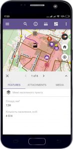
M1MT: Interactive village map – is a modern tool for managing the main treasure of the Ukrainian village – it’s land and labor resources. The interactive map displays the spatial information that is relevant for each manager in the village council office with the possibility of operating with thematic layers of the map and editing the content. The effectiveness of the use of interactive maps is achieved through a flexible database, supplemented reference information (descriptions of the depicted objects, numerical data, photographs, etc.).
Web map features
- navigation on the map, data editing, operating with vector layers of the map, spatial analysis, address search;
- to work, the user does not need specialized software and qualification of a cartographer, it is enough to have a web browser and an Internet connection;
- easy search, quick update and edit the database;
- constant readiness for work;
- protection of information from distortion and unauthorized access;
- management of the company’s vital processes from a mobile device (smartphone, tablet);
- monitoring and assessing the quality of duties performance by the relevant services (social, communal), remote workers (inspectors, auditors, land surveyors), village council leadership;
- monitoring and processing of citizens’ requests through an electronic survey system.

